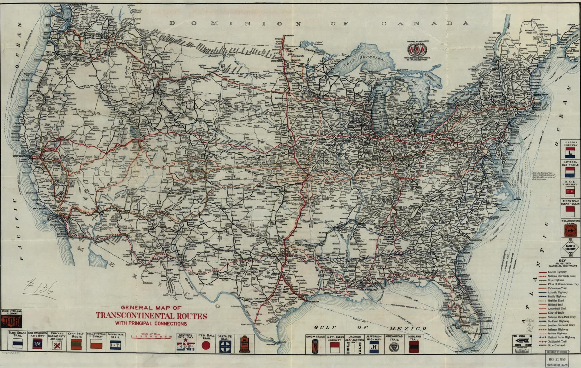
I was just looking at some early national road (and rail…) maps and wondering what it would take to coordinate an effort for national coverage of something like this 1918 AAA map with all the old road names on it:
I think these would both be cool representations of a nationwide road system, one prior to the national interstate system, and one prior to even a national marking system.
Once we have a framework / scaffolding like this, it’ll be easier to hang other data on and around these roads, like the recommended amenities of the Victor H. Green Negro Motorist Green Books.
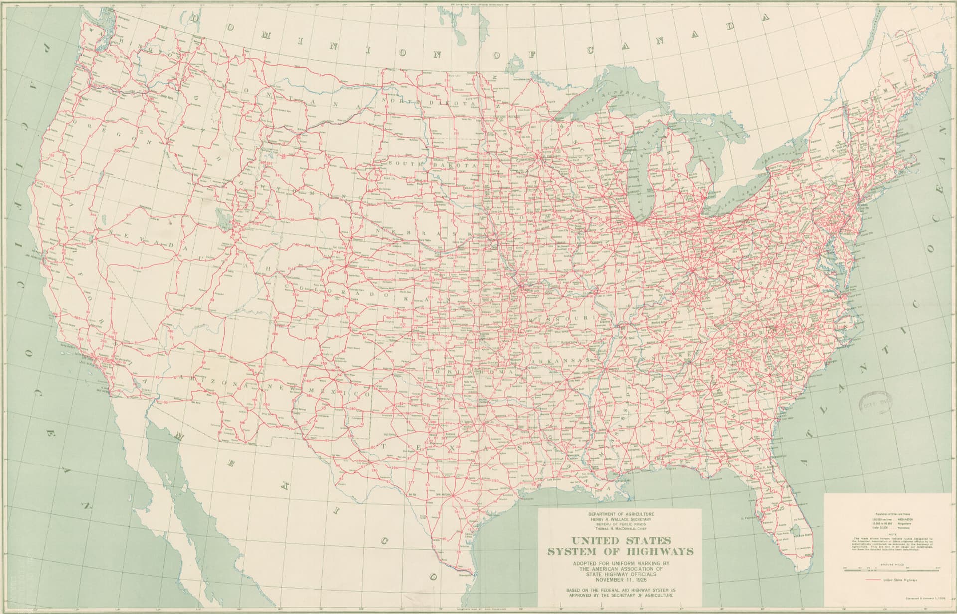
Or, we’d have some even more detailed, rich versions of things like these maps.
Welcome to the Forum, @SherbetS! Great to see you at State of the Map and also great to see you here.
I bet there are vector files for these old roads… as they’re probably quite identical / overlapping / contained in modern roads. I’d be surprised if they’re in Wikipedia, but who knows? Perhaps there’s a central nationwide source for roads? Something thtat pulls together each state’s DoT information? I’m not sure what would be preferred…
That’s are sort of my questions for the group… even if we had these vector files, what’s the right approach for:
Tagging the roads?
Should the Lincoln Highway be marked as a highway=trunk? It doesn’t seem like highway=motorway would be appropriate.
What other tags should be assigned, as a project-level template?
Organizing the roads?
I’m not a road mapper, so I’m not sure what the appropriate organizations would be, or how to assign them ref=*, etc.
Styling them?
Right now, highway=trunk shows up on OSM at zoom=6, which ‘feels’ right to me, but they don’t show up on OHM until zoom=7. Is that the desired behavior?
Something I should have added to the OP, having a map of all of the primary dirt roads in the US would be amazing and unique, as well as some depiction of how those roads transitioned across the country during the Good Roads Movement would be unparalleled.
Thinking about this while reading Slack #tagging discussions has made me realize most roads have not belonged to networks (the basis of the OSM highway=* taxonomy) for the majority of history and we may need an old road tagging guide of some sort.
Adding to the project needs list:
Old Roads tagging guide
Detailed road lifecycle documentation
Any pre-highway (or, highway for that matter) historians around these parts?
You can’t really use motorway before the autobahn since it is a physical classification as opposed to a functional classification like all the other classes. Trunk can definitely be used for historic roads, even if their physical characteristics are nothing like trunk roads on OSM now, since it’s a functional classification (roads that link major population centers)
I’d definitely be interested in seeing some historical road mapping. There’s a lot of history there with little online record from what I can tell
I don’t know if I would consider myself an “expert” but I have been slowly been working through Oklahoma DOT’s state map archive and I have a few thoughts
My first is that we will need something more detailed than a national level map to work off of, routings through cities can be complex to navigate even with more detailed maps
Secondly, the OSM method of symbolizing highway numbers utilizing the “ref” tag won’t work as well in OHM due to the frequency of number changes. I think it can be solved with a relation, but would love to hear further thougthts
Finally, I have been roughly sticking to this as my guideline for tagging the highways. I think their symbology is good with the exception of “Secondary” where I want to see more of a distinction between a secondary highway and a tertiary highway
“Motorway”=Interstate Highway or other limited access freeway
“Expert” status is not necessary. : ) Willingness to put forth a plan and collaborate around an approach is much more highly valued!
I’m 100% amateur or beginner on road mapping, so are there any perspectives on the use of something like the National Transportation Atlas Database as a first cut to compare against old maps? My guess is that all or most of these old roads persist to this day, perhaps under different designations, etc.
I think it could work if we set the initial “start date” as a future date and then working our way backward and sourcing the actual start date. I think that approach will leave a map that has a lot of gaps in its road network, especially as you get earlier than 1960 when the interstate highway program was in full swing
Its a bit more of a manual process, but if we could digitize some of these old state DOT maps from the various states, I think that starting in the 1910s and 1920s with that information is a better processes. I know there is software that can extract vectors from raster images, but that is a bit beyond my level of expertise
Agreed. These national maps may be useful as guides to when certain routes were in existence, but we’ll have to supplement them with more local maps for the geometries and written publications for the start and end dates.
In the past, some OSM mappers (particularly NE2) have mapped auto trails as route relations based on old guidebooks in Google Books. But since OSM only maps extant road infrastructure, the route relations reflect essentially where you’d go if you wanted to “clinch” the old alignment of a route without straying too far from a current highway and trespassing on private property. By now, some of NE2’s route relations remain, and some have been deleted. They’ve released their work into the public domain, but I’m not sure we’d be able to use it directly anyways. More likely we’d consult the sources they cited in OSM (which OSM has no proprietary rights to).
Yes, many state DOTs maintain extensive libraries of old highway maps, route logs, and minute orders. If you let them know what we’re up to, they’ll probably bombard you with more than you’ll know what to do with. On the other hand, some of the states’ older maps are extremely crude, a far cry from today’s GIS layers and straight-line diagrams.
Old topographic maps are also very useful for tracking road development, with the caveat that the USGS was sometimes a few years behind the construction of some major roads, depending on when they got around to updating a given quad. Unfortunately, we haven’t integrated the USGS topoView layers into iD yet, but there is a manual workaround in this ticket:
In my limited highway mapping so far, I’ve started with roads I know well. For freeways, I track down articles in newspaper archives about groundbreaking ceremonies and ribbon-cuttings, then trace from modern aerial imagery, cross-referencing the built-in Esri Wayback imagery and USGS topo map layer to make sure I’m not glossing over a realignment that has taken place since opening.
Many freeways used to be known primarily or exclusively by a conventional road name, distinct from any route number or memorial name designation. These conventional names can be very useful for finding articles about freeway openings. For example, Interstate 275 in Ohio is formally known as the “Circle Freeway”, but this name has never been signposted anywhere. Roadgeek sources tend to gloss over this name in favor of the memorial name designation based on it, “Donald H. Rolf Circle Freeway”, that is minimally signposted. Yet references to “Circle Freeway” abound in newspaper archives, years after Rolf was honored in this way, often without mentioning I-275.
For other highways, I’ve found the AARoads Wiki (née English Wikipedia) to be useful starting point for research, since many articles contain sources with precise dates. However, there are also many undersourced articles that one can only take with a grain of salt. I’m hoping to interest the AARoads Wiki folks in building up OHM’s highway coverage in concert with their article editing.
I’ve also mapped some city streets, which can serve as a backbone for mapping route relations through town. In any city laid out as a neat grid, I’d start by determining when the town was first platted and mapping the grid en masse. Name changes and closures of specific street segments are often mentioned in passing in the context of something else, like an annexation or urban renewal project. In one area where I map, there used to be a local newspaper column called “How Was It Named?” that will be a boon for mapping street name changes, once I get to it.
We shouldn’t fudge any dates or rely on impossible leap days or future dates. These practices are brittle and difficult for data consumers to detect and filter out. Instead, let’s use start_date:edtf=* to record any uncertainty about dates, such as 1957?, 195X (1950s), or 1957/1959 (between 1957 and 1959). Then start_date=* can be a “resolved” date within the range specified by start_date:edtf=*, just for the purpose of having something to render.
Auto trails like the Lincoln Highway would’ve been good candidates for highway=trunk until the development of the U.S. Numbered Highway System. Many roads were part of both an auto trail and a U.S. Route, so the highway=trunk classification would’ve persisted in general, though the precise routing through cities would’ve varied a lot over time.
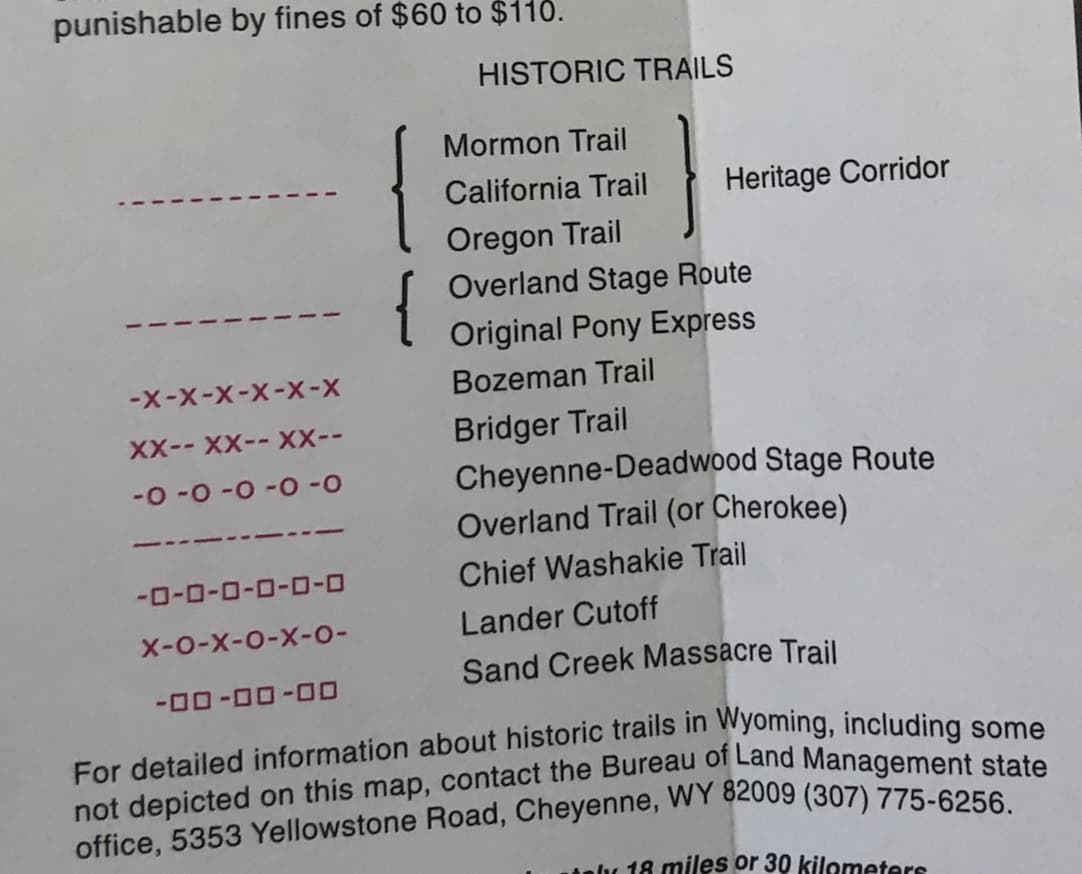
Some of the auto trails predate automobiles, so that’s a nice way of extending highway=trunk even further back in time. The National Road (Cumberland Road) overlaps with stagecoach routes in the West, which are also similarly prominent. Wyoming’s official transportation map prominently denotes historic stagecoach routes, so there’s probably decent sources for many of them, either as maps or in textual form:
Yes, I’ve seen folks sticking route numbers in ref=* or even name=* on individual highway=* ways, but I think of that as nothing more than a shortcut, just to jot down the information without losing track of it. Route relations are much more versatile for this purpose. As in OSM, you can add a given roadway to multiple route relations. But in OHM, these route relations can also represent the same route in different time periods.
OSM’s U.S. community has been talking about way refs as a deprecated or at least outmoded tagging scheme for 14 years now. In fairness, route relations are more complex to manage than way refs, but once our renderer starts processing route relations, it’ll be possible to do something more intelligent with them, like rendering historically accurate route markers in a road atlas style.
Looks like this should be: Way: Federal Road (198771334) | OpenHistoricalMap. If you make a route relation for the Federal Road, you can move the destination:forward=* and destination:backward=* tags to to=* and from=*, respectively, which will be less fragile than tags on a way that will inevitably get split up into smaller segments.
Okay, as I have thought this out further, I think the best way to move forward with a national project is to start with the Interstate Highway System and use the National Transportation Atlas Database that @jeffmeyer mentioned as a base and then use the state DOT maps and information to confirm the construction dates
I think then a logical step 2 is to use the same state DOT maps to map out the highways that pre-dated the Interstate route through an area. Sticking with the example we’ve been using, our workflow would go Interstate 80>US Highway 30>Lincoln Highway
I used a version this workflow pretty successfully in Oklahoma to map out the route of US 66 and its upgrade into I-40 across the western part of the state
The AARoads Wiki maintains a comprehensive index of meeting minutes of the Special Committee on U.S. Route Numbering at AASHO/AASHTO, which is responsible for officially designating federal routes (U.S. Routes, Interstates, and U.S. Bicycle Routes, and special routes thereof). The minutes of each meeting also has its own Wikidata item, which you can cite as source:wikidata=*. Some states like Texas also post searchable archives of minute orders online, which saves us the hassle of looking for contemporary news articles.
The dates associated with these minutes relate to a route rather than the individual roadways that carry the route. However, an Interstate usually isn’t designated until the freeway has been fully upgraded to Interstate standards, so it often constrains the highway=motorway’s dates too.
If we do attempt a large-scale import of an existing road dataset, especially a snapshot-in-time dataset, we should improve upon the process used in previous road imports such as in Santa Clara County so that this fledgling community isn’t left with more cleanup work than it can swallow. We also urgently need to resolve some best practices questions, particularly how to model changes over time to attributes besides route designations.
For the time being, I would favor making it as easy as possible to use NTAD as a comparison layer or importing it piecemeal without directly importing it in bulk. For our road coverage to be a serious resource, it needs to be granular down to individual alignments and realignments, not just putting one date on an entire cross-country route. In many cases, this will require researching a road more intensively than what the Wikipedia article provides. A bulk import may obscure opportunities for deeper historical coverage.
Lots of stellar work has gone into the road coverage we do have. I think much of it is motivated by the desire to light up roads on the map, but some of this motivation would be swamped by a bulk import.
I don’t think that will be difficult, as it wasn’t really a process beyond just importing a local municipalities’ roads GIS file. It was not really even a planned road import, more of filler context required for a demo of OHM in the Palo Alto / Stanford area.
For that area - and others - I think we should be ready to remove existing roads that have not been brought in in ways that are conducive to historical mapping or if they contain so many mistakes that they require too much work. For example, how would a statewide road import handle integration with existing roads? Should we “cut a hole” in the data where some already exists? Or, should we just worry about mapping the main highways that would show up at a national zoom level and leave it to local mappers to fill in the more local information? We should, of course, consult with the contributors to the roads already mapped in every case.
Is this something we could do with Rapid? Not only expose as NTAD as a visual comparison, but also as a data source for… rapid… addition into OHM, with instructions for anything to watch out for?
Isn’t granular down to individual alignments and goal and the original lines that will need to be modified a starting point? I think there’s tension here between the separaate, but related, goals of “lighting up the map” and “being a serious resource”, but won’t we be in between the two for quite a while? How do we support either objective in a way that doesn’t block the other?
And, as we go back farther in time, most of these roads will be just lines. For those older roads and routes, many of which have turned into modern roads, esp. in Europe, we should have a plan for how to treat those as they eventually modernize.
Maybe we should have a skeleton / topological backbone that slowly gets replaced / updated over time with the more modern information? Or, treat them as two separate data structures, one as a logical sort of network and the other more “as built”?
In some cases, we probably could avoid conflicts by excluding a state from a road import – such as Oklahoma, thanks to @okiewxchaser’s work on state highways there. But other mappers have instead focused on mapping a particular long-distance route end to end, such as Route 66, which makes any geographical filter more challenging. I think any import or quasi-import would be most effective if it adds individual routes from end to end, wherever they happen to go, similar to how NHD and 3DHP imports are segmented by watershed.
Sometimes it is possible to add a roadway dated and sourced as a whole: for example, Interstate 71 between Cincinnati and Columbus opened all at once one morning:
I would’ve been justified in mapping the whole segment as a single roadway, as a first pass, though I couldn’t resist adding more details along the way like bridges and ramps that did not all open at the same time.
If someone were to drop in the entirety of U.S. Route 99 from Canada to Mexico and apply a single date to the whole route, even as a placeholder, it would result in severe anachronisms no matter what date they choose and possibly lead to confusion among mappers as they try to orient themselves and find sites along the route.
Rather than importing anything directly, I think the most effective way to facilitate road mapping would be to collect and collate both old maps and published descriptions of roads and their opening dates to use as references. At the same time, we should emphasize to mappers that they don’t have to micromap the highway upfront down to lane-level detail or get the curved geometry just right. I think this may be a common misconception among mappers who are used to OSM norms.
Overall, I think making progress in this topic will probably be measured in terms of how well we prioritize the most important routes, rather than how dense of a network we’re able to build, at least at first.
Yes! This would be amazing, even if the source maps might take some time to assemble.
It seems to me that old county road maps might be the best place to assemble this source material. For example, I love maps like this 1938 map of Harnett County, NC.
To this point, I’ve put a very rough draft of a project page together for Route 66 and there’s already one for the Lincoln Highway.
Perhaps someone can jump in and add additional direction. Ideally, I think we can come up with an approach that isn’t overly burdensome, but also won’t set us up for some less enjoyable fixing later? And, it would be great if these instructions were to become a template for use on other roads.
My thought is that we prioritize the Interstate Highway System (and the major routes at that) for a “quick win”, but still allow a space for folks who want to work on concurrent projects where it makes sense (like US 66 and I-40 in New Mexico for example)
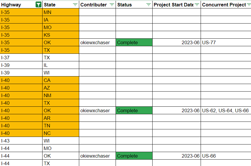
Please advise best location and method for hosting this spreadsheet
I’m getting a bit of déjà vu, in a good way. One of my first memories of OSM was helping to knock out some of the entries on the wiki’s giant table of Interstate route relations, and similar state-by-state tables. If it isn’t too much trouble, you could create a similar table on an OHM project subpage. I think the visual editor mode lets you copy-paste directly from a spreadsheet application into a wiki page without losing much formatting.
If you prefer a more user-friendly spreadsheet, you could put it up on Google Sheets or an open-source, login-free alternative like EtherCalc.
Minh’s suggestions are quite good and it looks like you also already have a system. If you don’t mind making that spreadsheet shared, or controlling access to it, we could use yours. If you’d prefer not to manage that, I can make a copy and share it, either openly or selectively.
Or, I’d be glad to convert it into a wiki table - as Minh mentioned, the visual table editor is much much improved over old-school Wiki editing. I’ve just come across it recently and am impressed.