I am wondering what is the best strategy to manage “moving” edges of water surfaces in time ?
Should we draw each piece of water surface that was present at one time and today ?
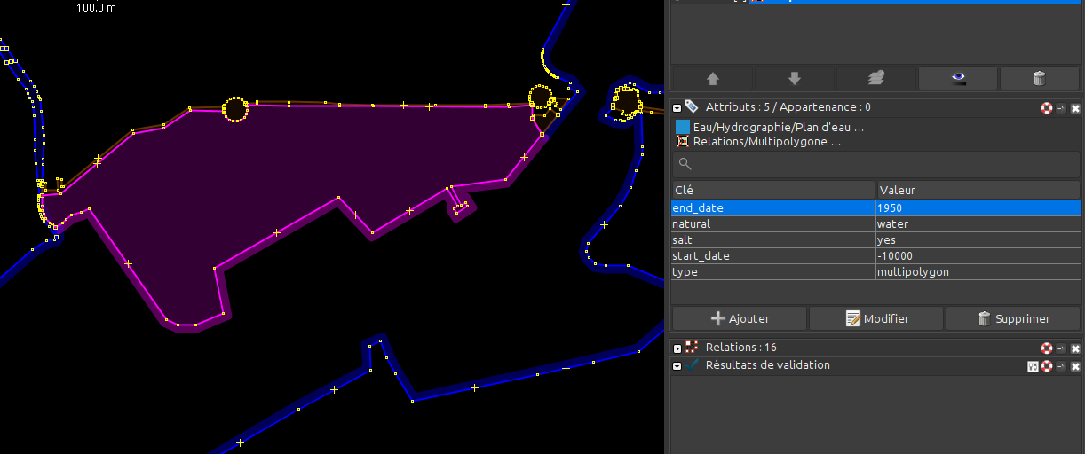
How does the end_date manages the suppression of a water surface ? (In the example below, it is not working. Could you help me to make it work ?)
Where should be tagged the coastline ? (on the farest edge in the sea ?)
Is the update of the coastline position still an issue in 2024 ? (before, it was never updated, which will ruin any modification performed with water connected to a coastline)
Hi @Stephane_V - great to see you here on the forum!
There are probably a bunch of ways to map the water surface that was present before & now is not. We haven’t put together a best practices doc on that and probably should.
For your example, I think it’s working now, but I didn’t test it as well as I should have before I edited it, so it might have been working?!?!?
The only thing that looked odd to me was that it had start_date=-10000, which should have been fine, but is also optional. Leaving no start_date value just means that it’s been there since as far back as we can tell (without adjust sea levels for the ice age, etc…)
For your questions:
I’d draw each piece of water surface separately, but these can change significantly over time, so you may have many versions of the same water area.
end_date=* should work like it does for other features - buildings, roads, etc. If something’s not working, please bring it up here!
For now, we should probably just leave the current / modern coastline tagged with natural=coastline.
Yes, our current coastline process is messed up and needs to be repaired, but that’s a pretty large project that will need some coordination. You’re correct that it will complicate moving shorelines until that’s fixed, but I don’t think it will be impossible.
Please take a look and let me know if it is working for you!
Lake Duwamish and Lake Washington change lake water levels.
I also am working on a lake in the center of America where a dam is built and there is a normal lake level and a high water level. I am not sure what dates there are for the high water but its clear from imagery that the “normal” lake level is far higher than that listed in the USGS TOPO and I am not sure how to edit that change without knowing more about the dates.
Sorry to bring up this old topic, and sorry if I missed something, but what exactly is the current coastline process? It seems to me they’re just rendered from OSM, or is there something more nuanced going on?
Yes, I think that’s correct. The vector tiles contain a layer representing landmasses that’s based on a dataset of land polygons published by FOSSGIS based on OSM data. Separately, the OHM database contains an old import of OSM coastlines that predates OSM’s migration to the ODbL. (In fact, it’s actually largely public domain data from an external source.) There has long been a desire to integrate OHM coastline data into the OHM vector tiles, but In the meantime, mappers have been implementing coastline changes by patching up the coastlines with natural=water areas.
As far as I know, there was an attempt to apply OSM’s coastline processing pipeline to OHM, ignoring differences over time at the outset. But the effort stalled because there were a lot of broken coastlines. Maybe some of the breakage is due to variations over time, which the software doesn’t account for, but we’d need someone to take a look and understand the prevalence of actual mapping errors.
I don’t know what the plan was for rendering the variations over time. Maybe our more recent work on boundaries would be more straightforward to apply to the coastline problem, obviating the earlier work. After all, OSM adopted the natural=coastline tagging scheme and an extremely fragile coastline processing step so that mappers wouldn’t have to maintain equally fragile relations. But we unavoidably maintain boundary relations spanning continents and beyond. Alternatively, maybe the hack we’ve been using isn’t such a hack after all, if we can convert the space in between the coastlines into bite-sized landmass areas or the inverse at sea.
If it’s broken coastlines that prevents OHM from rendering coastlines, I’d be more than willing to help fix those. Or help in any other way with coastlines.
I think the OSMCoastline tool we experimented with for generating the coastlines effectively doubles as a QA tool for broken coastlines. If you have enough disk space to download the OHM planet, you should be able to run this tool and get a list of errors pretty quickly.
While we’re on this topic, I should note that we’d ideally be replacing the coastlines we do have with some other source besides old OSM. The existing import from OSM is theoretically encumbered by an old version of a Creative Commons Attribution–ShareAlike license that has known issues, though with the caveat that most of it is likely based on public domain work anyways. I’m hopeful we’ll be able to produce much higher-quality coastline data independently of OSM over time, based on imagery sources that weren’t available to OSM back then and other sources about historic shifts that OSM would never have considered.
Yeah, it took me like a month to fix the coastlines in Belize on OpenStreetMap. It would be preferable to start with a clean, more accurate slate. But then all coastlines that have start and end dates already would have to be carefully attached to the new import, which I would be willing to help with.
I don’t think coastlines – in general… for now – should not have start_date or end_date tags on them.
This assertion assumes the following (which could be right or wrong… let me know!):
Our ability to ascertain a pre-man-influenced coastline as a baseline of some sort and that would pre-date (by definition) man-made change.
All subsequent changes could / should be modeled with water or island-based additions / subtractions, etc.
All prior, natural changes, due to sealevel changes, natural disasters, etc., could also be modeled in some other way.
The goal of this approach would be to have at least 1 “clean” coastline (clean, as in no piers, landfills, etc.; also clean, as in CC0, but 1 step at a time), that we could use as a foundation.
Well, it’s no different than mapping rivers as far back as we know them. But I do believe coastlines would be constantly broken if we kept modifying them. If I’m correct OSM has constant issues of broken coastlines, I myself have broken them countless times.
Yes, it’s a problem with any large feature. OSM’s coastline processing gets stuck regularly as each questionable change is brought before the community for resolution. Though it’s a separate kind of feature, the Great Lakes go missing just as regularly. Here in OHM, national boundaries get broken so frequently that we’ve given up calling attention to it by hiding the boundary and instead just show incomplete boundaries.
That hadn’t occurred to me about the licensing encumberment, and I hadn’t heard about that CC licence bug, yikes!
If we do want to replace coastlines, I wonder is there a case to be made for going ahead and removing natural=coastline ways that haven’t been touched since the old-OSM import. It seems they don’t render under any circumstances, so their absence would probably be no more confusing than the current situation…
Well, there has to be a coastline for waterways to be attached to, otherwise the water areas might not reach the coastline properly. And if the coastline has to stay clean, then it would have to be locked to prevent nodes being moved. Though I am against this. I prefer being able to chop the coastline into a million pieces.
I mean, most of the waterways in Ireland don’t currently appear to reach the coastline properly, because sometime between the import and now, OSM’s natural=coastline ways were moved outwards at river mouths. Here’s where I fixed it in Cork (and it’s still slightly dodgy): Changeset: 159315 | OpenHistoricalMap
Technically you’re right that it wouldn’t break anything immediately, though I wonder if that would make it difficult to ever know if we’ve completely replaced the OSM coastlines. But we could replace each untouched coastline with VMAP0 or some other unencumbered source while we’re at it.
To elaborate, OSM started out with public domain PGS coastline data. Even a year after the vintage of the OSM snapshot we imported into OHM, it was estimated that OSM had only modified about half of the PGS data, mostly in Europe, Japan, Southern Africa, New Zealand, the West Coast of the United States, and the Canadian Maritimes. So we could potentially take a more nuanced approach, replacing just the portions that were modified away from PGS.