I know this is a touchy subject, but would there be any objections to me mapping the parts of Ukraine that were invaded by Russia in the past few years as Russian? My reasoning is that OHM is different than OSM in that we would usually map country boundaries to official occupation dates.
For those areas which were occupied since 2022 I would suggest to wait for an armistice. Even OSM did NOT manage to provide actual data about the wartorn area, as they suggest a three-hour drive between Mariupol and Pokrovsk.
Yeah, that makes sense. I’ll just do Crimea then.
Please do NOT map those areas as Russian.
Ukraine is a sovereign country that has disputed the Russian claims to and invasion of Crimea since “unaffiliated” little green men first arrived in 2014.
There is no treaty or agreement signed by Ukraine that recognizes the Russian presence anywhere in Ukraine as legitimate.
Until there is any such official resolution, my position is that it would be better to create a admin boundary relation with some sort of marking as disputed=yes.
This way, we would retain the official boundaries of Ukraine, which have not changed, as well as a depiction of the Russian perspective of their possessions.
We should probably have a discussion here on the forum about how to handle disputed territories generally - e.g. relations, rendering, additional tags, etc. - but I’d like that to be independent of this specific conflict.
I’m not sure we should mark occupied territories as anything other than admin boundary relations with both disputed=yes and occupied=yes, or something to that effect, but let’s put that in the separate thread, as well.
Last, there are a few sources of higher-frequency updates of the boundaries and fronts of this conflict, among them Nathan Ruser and LiveUAMap should anyone be interested in reaching out to see if they’re willing to share their historical data.
5 Likes
I don’t know how OSM does this, but for official borders I would follow whatever the majority of the UN thinks is right?
Perhaps we could include a rule to only map these things if they happened like 10 years ago or something? To steer clear of current politics but still be able to map the different areas occupied in WWII or so.
I like the way Indy Neidell from the YouTube channel World War Two (and others) once said it when asked if they would make a series on the current Russian/Ukrainian war in the style of their other war series: ‘we’re historians and we talk about history.’ He continued to explain that they’d need to read a lot of documentation from both sides to not fall for current propaganda etc to see the full picture of what’s happening there.
I think for delicate topics like current wars that may be a good ‘rule’ to stick to.
1 Like
I can see some strengths and some drawbacks to this suggestion, and am curious what others think about it.
Strengths:
- Keeps a temporal buffer between OSM and OHM
- Possibly keeps OHM out of any contentious contemporary debates
- Keeps focus on “historical” mapping
Drawbacks:
- Puts limits on what goes into OHM - for example, there are plenty of recent events that people might want to map that don’t have any controversy around them
- Recent history is still history - it limits the use of OHM for depiction of recent history; e.g. creation of new countries, movement of US Embassy in Israel, etc.
- Gives credence to storytelling that might be at complete odds with factual history. E.g., Russian occupation of Crimea since 2014 does not change the international recognition of Crime as belonging to Ukraine. An occupation does not change that fact. And… this example falls outside of the 10 year timeline. Same could be said for the Oslo Accords of 1994.
- The time window is arbitrary and not based on any transmutation of actual facts.
My personal take is that we should (a) not put any limits on what people put into OHM, (b) as long as it can be supported by internationally-recognized legal assertions (for borders), and (c) that we have a means of representing significant competing claims to the contrary.
Right now, I believe we satisfy (a) and (b) with our existing systems and that we satisfy (c) from a data perspective, but could use help in our rendering and depiction of disputed claims.
I’d reassert, though, that this is an important consideration and we should get more input from a wider range of sources. The thought that has gone into the discussion so far has been fantastic and nuanced - this is not a simple issue!
1 Like
What if we just had standards on how to map modern and evolving conflicts?
If an occupying nation has publicly stated that they have annexed a territory then tag that territory with some sort of occupation tag from that date (If they actually physically control the area of course).
I had this issue multiple times mapping historical countries as well. So I would prefer a tag for occupation zones (do we have such a tag?) and map those areas as such.
OHM would be so much more historically accurate if the time between annexation and the official treaty were properly shown and tagged on the map. Currently a lot of country boundaries are mapped with the time stamp set to the occupation date and not the actual treaty. Sometimes a treaty comes a hundred years after the actual annexation has happened (such as the Koreas still being at war officially)
Currently the occupation of Germany after WWII looks like this
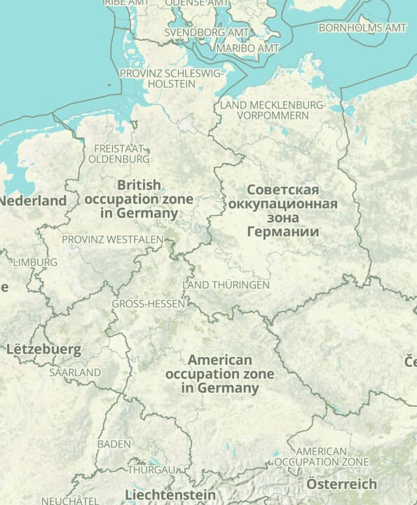
wouldn’t it be better if Germany was displayed as one country and then have a line pattern across the territory marking it similarly to how we discussed awhile ago marking disputed territories but maybe a different or bolder pattern.
1 Like
Just is doing a lot of heavy lifting there. I think we all want that, but to have a standard you need a clear idea of how to do it in the first place, and ideally a consensus on it. It also needs to be robust enough to cover all, or at least most, scenarios. Ideally it would be applicable to historical (but still “modern”) conflicts too, such as the World Wars or the Napoleonic Wars.
In a sense we do have a standard – don’t map claims that are part of modern conflicts as if they are “true” (so in this case don’t say/imply “these areas are part of Russia”). The reliance on multipolygon-type boundary relations makes it a little more complicated to do anything other than leave it unmapped as we can’t just tag the ways (at least not simply).
The post-WWII situation in Germany wasn’t quite the same as “modern and evolving conflicts”: after the German surrender in 1945 the allies assumed full sovereign authority over Germany and legally occupied it (by treaty, not unilaterally). There was no sovereign state of Germany during this period per se. In a sense “Germany” became a condominium of the allied powers under the Allied Control Council, but with each zone directly controlled by a specific power. There are also no universally agreed upon boundaries for it – the Allies recognised the Oder-Neisse line as the eastern border but from its founding (1949) until 1972 West Germany claimed all of Germany as it was until 1937, i.e. including East Germany and the areas east of the Oder-Neisse line: East Prussia, Silesia, Pomerania etc.
I do agree though that mapping the occupation zones as equivalent to sovereign states also doesn’t seem right. Incidentally occupied Austria is mapped currently as a single admin_level=2 entity and its occupation zones as admin_level=3. To be fair though its boundaries were clearly defined and never disputed.
I have written quite a lengthy post about boundaries like that (and fiefs, disputes, condominia, unions etc) which I will be posting soon.
1 Like