Anyone have a working example to share of how to use OpenHistoricalMap’s vector tiles in OpenStreetMap’s iD editor’s Data Layers → Custom Map Data function?
I haven’t tried it yet, but OHM has a public vector tile endpoint that you should be able to plug into iD’s custom data layer dialog, since the tiles are in MVT format. Unfortunately, iD’s default layer styling may make it a bit tricky to work with at a small scale or in an urban area, since OSM’s iD doesn’t include a date filter.
Thanks, I tried the following:
https://vtiles.openhistoricalmap.org/maps/osm/{z}/{x}/{y}.pbf (with z, x, y values plugged in)
But couldn’t get it to work. I am caveman when it comes to code.
My use case is to pull up OHM while editing in OSM to see if a historic feature observed in terrain or usgs topo background layers has been mapped already in OHM (abandoned railroads specifically).
Make sure you enter the URL format exactly as shown; don’t copy the text as a link, because your browser will replace the curly braces with percent escapes.
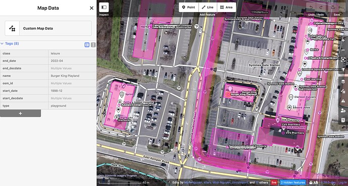
Here’s what it looks like:
The “tags” are just whatever feature properties are in the tiles. This tileset transforms the tags into properties more suitable for display than editing. For example, leisure=playground becomes type=playground class=leisure. Expect more departures from raw tags in the future.
Many tags aren’t exposed in the tiles for performance reasons, or just because no one has gotten around to exposing them yet. In particular, the license tag is dropped. You might want to perform an Overpass query first or open up OHM’s iD in parallel, just to make sure you don’t accidentally put Creative Commons Attribution–licensed material in OSM without getting a waiver first.
As I mentioned, there’s no way to filter by date. There’s also no way to peek at a feature that happens to underlap another feature.
