Hello together,
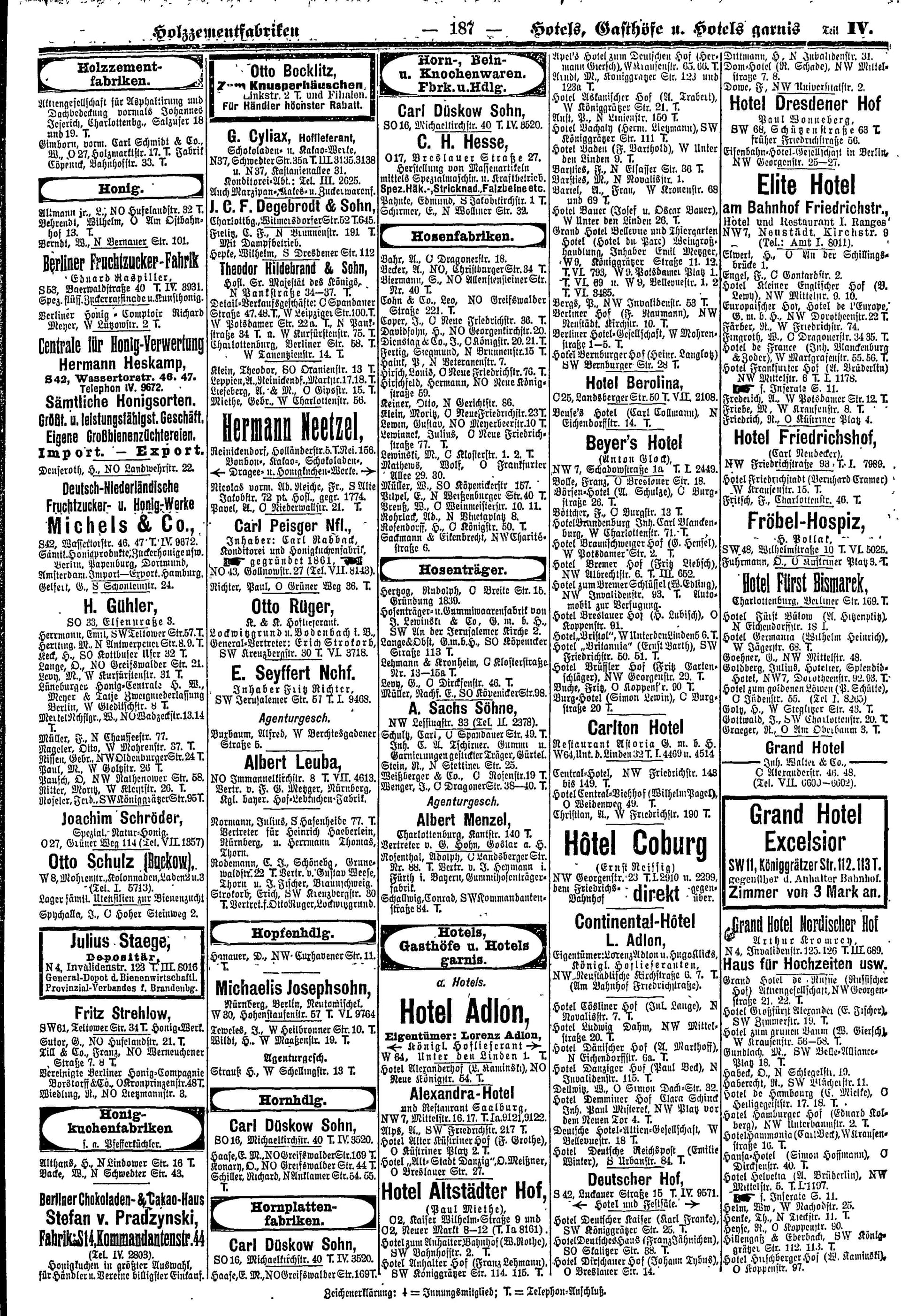
in the last time I mapped Hotels from the Berliner Adreßbuch from the year 1910. Here ist an exerpt of the Adressbook:
I started mapping with the ID Editor. Later i used JOSM with a for that purpose made preset. I searched for the historic/former street names on the fly. Doing that the Website Straßennamen der Berliner Stadtbezirke was very helpful. The Hotel Names and Addresses were sourced from the Berliner Adreßbuch from 1910 and were compared with the Straubeplan from 1910. Using both resources from the same time period i was mitigating mixing up possible address changes.
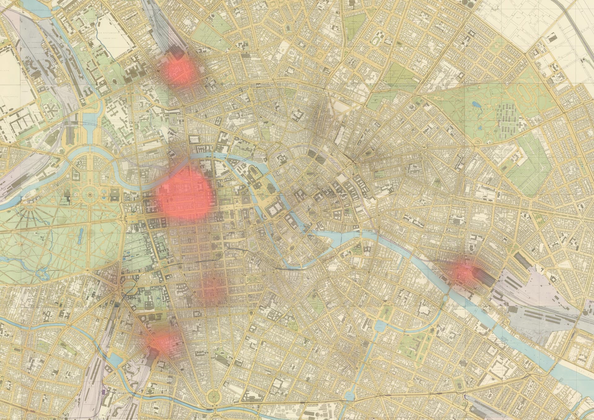
From the data i collected i put together a Heatmap in QGIS. Included in that heatmap are also some hotels sourced from historic postcards from eBay. The background layer of the Map is the so called Straubeplan from 1910.
As you can see in the Heatmap, most Hotels were located around railway stations. The most prominent cluster can be found around the Bahnhof (railway station) Friedrichstraße in the center of the map. In the north is a cluster aorund the Nordbahnhof. In the south aorund the Anhalter Bahnhof and in the East around the Schlesische Bahnhof.
Feel free to share my post if you like!
Best regards
Benjamin K.
3 Likes
Wunderbar! Here’s a query for the raw data on hotels in Berlin as of 1910:
2 Likes
Hi Benjamin - Minh is correct - this is fantastic!
One question - you mentioned you were using a JOSM preset - is that one you made yourself, or one that already exists? I’m sure others might find it helpful.
I just love the idea of integrating old business directories into our maps. It really creates a very rich environment!
Hello Jeff,
thanks for your feedback. I totaly agree with your assesment.
I made a custom preset to not always have to type the source:name, source:date, source:url etc. I attached the xml of the preset below. Hope somebody may find it helpful.
Best regards
Benjamin K.
<presets>
<group name="Historic Hotels">
<item name="Historic Hotel" type="node">
<label text="Historic Hotel Details"/>
<key key="tourism" value="hotel"/>
<text key="owner:1910" text="owner:1910"/>
<text key="name" text="name"/>
<key key="start_date" value="1905"/>
<key key="end_date" value="1915"/>
<key key="source:name" value="Berliner Adreßbuch 1910"/>
<key key="source:date" value="1910"/>
<key key="source:url" value="https://digital.zlb.de/viewer/image/34115495_1910/4917/"/>
</item>
</group>
</presets>
2 Likes
Based on these tags, I take it that the Berliner Adreßbuch was published every decade or so? If an appearance in the 1910 issue establishes a hotel’s existence on that date but doesn’t necessarily say anything about when the hotel opened or closed at the listed address, then it could have EDTF tags such as:
start_date=1905
start_date:edtf=/1910
end_date=1915
end_date:edtf=1910/
This will make it clearer that 1905 and 1915 are conservative placeholders for more precise dates. Since you used the same preset for each hotel, you can download them by an Overpass query for node["source:name"="Berliner Adreßbuch 1910"], select all the objects in the layer, and paste the start_date:edtf=/1910 and end_date:edtf=1910/ tags onto them.
The Berliner Adressbuch was published from 1799 to 1970
Berliner Adressbücher | 1799-1970 - Digitale Landesbibliothek Berlin
From 1952 it includes only Berlin West.
Old versions are printed in Fraktur (font). That makes any OCR process complex. @Benjamin_K Do you how whether its possible?
Ralf
Hello Minh,
i tried to add the missing edtf tags with that query for 174 nodes:
[out:json][timeout:25];
relation(id:2692240);
map_to_area;
nwr["tourism"="hotel"]
   ["source:name"="Berliner Adreßbuch 1910"]
   ["start_date"="1905"]
   ["end_date"="1915"];

out geom;
but i got this error message:
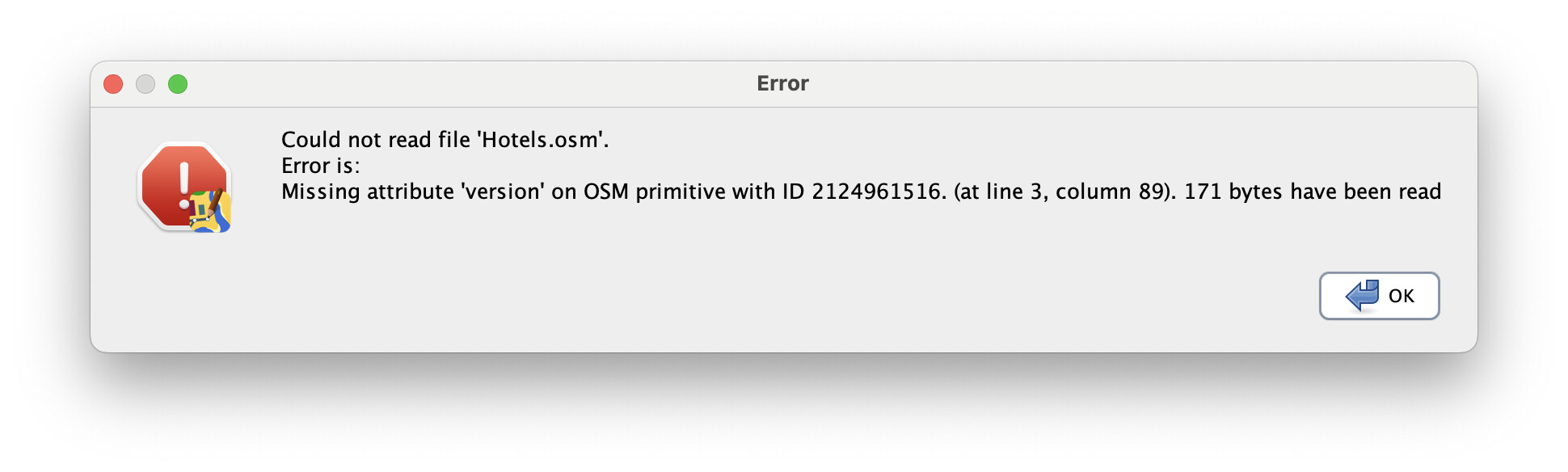
Der OSM-Server »https://www.openhistoricalmap.org/api/0.6/« meldete eine fehlerhafte Anfrage. Fehlermeldung (englisch): Version is required when updating Node 2124961516 at line 3, column 76
Do you possibly know how to fix the error?
Best regards
Benjamin K.
Are you seeing this error in JOSM when uploading the change, or at some other point?
Edit: I see that this changeset wound up empty, so I guess JOSM did fail to upload the changes. If the problem continues, can you share a .osm file of the changes? I wonder if there might be a conflict that isn’t getting resolved correctly.
Thanks for sharing your .osm file. I get the following error when attempting to open it in JOSM build 19369:
If this file was generated by a recent JOSM version without any subsequent hand-editing, I’d suggest filing a JOSM bug report.
Otherwise, hopefully you can recreate the changeset without too much trouble.
Hello Ralf,
i am not familiar with OCR. But there are OCR models for fraktur: Deutsche Fraktur 19.-20. Jahrhundert - Öffentliches Transkribus AI Modell
I guess there might be other Problems like extracting the data in structured form or the correct interpretation of the semantics of the document. This probably requires AI.
An then you need to geocode the information, which perhaps requires a database with historic addresses and street names, which certainly does not exist in that extent yet.
Best regards
Benjamin K.