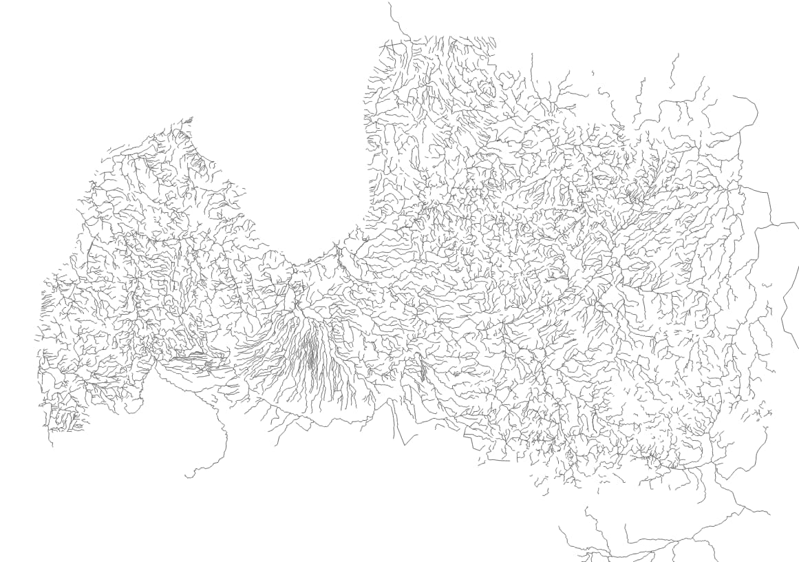
Would be a decent replacement for the old OSM water import in Latvia. Atleast for ways, dunno about the riverbank areas.
Not the most precise but very good with names, alt names and where along a river names change
Long-term, a lot of the original water import should be replaced by newer, super detailed, ideally public domain data, but if it’s easy enough to replace it with this dataset, then we can continue to iterate in the future. Do you see any difficulties at a glance? Have many of the waterways already been edited or added to relations?
Looks like mostly the borders with Lithuania and Russia that have a ton of relations using rivers. Really doubt much has been edited though.
International names might be difficult. Weirdly the latest version of the data no longer has a ‘country’ field. I can upload my 2022 copy.
If an international boundary has been joined to a river centerline, that probably means no much thought has gone into where in the river the precise legal boundary is located in relation to the river, since in reality it rarely lines up with OSM’s representation of river by definition. I suspect it would be safe to transfer the relation memberships to any replacement way.
Normally, I’d suggest using JOSM’s Replace Geometry tool to streamline the process while keeping revision history. But in this case it would be cleaner in terms of licensing if we remove the history of that earlier import.
One other thought… given that @Colby is looking to replace the rivers, why not just leave the existing relations as is, but remove the waterway tags from those ways? Seems like less work than redoing (or transferring relation membership).
Of course, those waterways make have different spatial properties, but that might be solved more cleanly by leaving the country relations as is, and then moving the relation boundaries to more precise (potentially more modern & historically inaccurate) way representations later.
Finished the processing into something that can be imported into OSM.
Needs a bit of tweaking such as adding “natural=waterway” because i couldnt figure out how to do that in QGIS (it kept thinking i wanted the value of “waterway” copied over), “name_ee” changed to “name:ee” and a few waterway category oddities translated to OSM tags but it should be pretty much good.
Where can i share the .shp to get the import started?
That could be a temporary step to avoid burdening the import, but I think we wouldn’t want people to think the precise alignment of these boundaries has any particular meaning apart from following OSM. So we’d have to retain a geometry:source=OSM or similar. Eventually though, transferring the relations to the newer ways would allow us to delete elements subject to the older license.
If you have a GitHub account, you could upload it to a repository there, or zip it up and attach it to an issue in our issue tracker.
Do you intend to upload the whole thing in one go? It might be safer to break it up by watershed or grid cell. Is there an attribute on each feature that you could spatially group the features by?
Can you document your tag mapping somewhere, either here or on the wiki or in a GitHub issue?
Also, if you convert to .osm format, you can apply tag transformations more easily in JOSM.
Oof. Just had a closer look at the data in JOSM and its actually kinda sad. Lots of ways going the wrong direction, barely any tributaries are properly connected. Bunch of validator errors about duplicated nodes, overlapping segments and so on.
Well atleast the name info is solid…
That’s unfortunate. Is the scale of the problem manageable? If you can find a way to split up the file by region or watershed, then we can load it into the tasking manager and instruct others to clean up the data as they help you upload it.
Also, do you see these problems with the most current dataset too, or only the 2022 copy you had stashed away?
Its the entire country but most of it would be relatively quick to fix. Still tons of work.
Latest dataset misses out on Estonian and Lithuanian rivers and names (except a few that for some stupid reason have them in the alt_name field) but river flow direction looks correct. Other issues still there.