What are your thoughts on the etiquette around removing these label points? Especially around label points for relations you haven’t created or edited, in areas you might not normally do a lot of mapping?
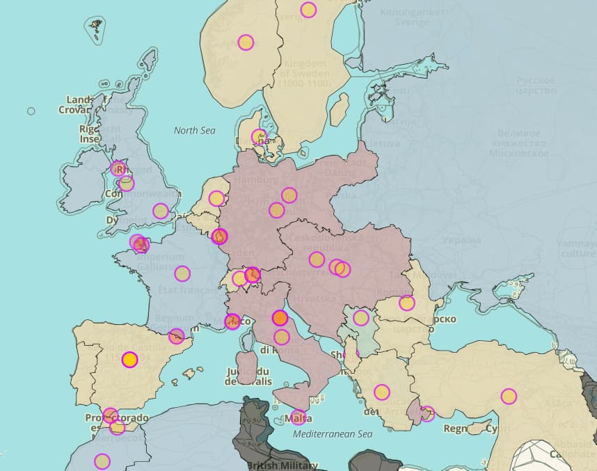
For example, I’ve been playing around with styling period specific maps (see below) and there is pretty uneven coverage of polygons with label points. I do like the fact that I can get a label point “for free” if I download data using Overpass, but I also know the generated label points are available through the vector tiles…
In my opinion, label points should be moved manually in order to avoid interference with large cities (e.g. Innsbruck and Tirol). In Austria, I tried to move them to unpopulated areas.
The label points we’ve traditionally placed at centroids are currently getting in the way of efforts to more intelligently label countries. These efforts essentially require us to go around deleting label points of countries and such (but not of settlements such as cities).
Manually shifting centroids to less populated areas can serve as a workaround, but this workaround falls apart as soon as the user zooms, rotates, or tilts the map, or if they use a language that calls the countries by longer or shorter names. (The embed site supports all these variables and more.) Deleting manual label points would enable the renderer to try multiple placements for each label based on the current map state:
Automatic label placement is an art and imperfect science, so it’s good to have the option to manually override spectacularly bad placements. But hopefully we won’t have to pour too much effort into manual placement. Once some of these improvements land, I encourage you to test the waters and try deleting some label points that are less likely to conflict, working your way towards ones that might conflict more easily.
Along the way, you’ll also want to delete date ranges from name=* so that they don’t show up in the rendered label. Otherwise, users won’t be sure if the date range refers to the lifetime of a particular boundary configuration or the polity overall.
I usually delete country labels, though I have seen some instances where they should remain, such as the Kingdom of Denmark showing it’s label in Iceland instead of in Denmark. While cities I use the OSM way of doing things by having a node for the admin_center.
Yeah, that makes sense. We could probably add some kind of heuristic that generates multiple “centroids” for any multipolygon ring that’s substantial enough, akin to the two label nodes on Michigan. Then a style could label only the ring that contains the capital (admin_centre or capital=*) with the main label; the other rings could get a less prominent label with “(pt.)”.
Yep, keep doing that, but use label, not admin_centre. admin_centre is for capital cities of political subdivisions, but a city usually doesn’t have a capital city inside it.
For that matter, I’m personally kind of disinclined to use admin_centre roles even for capital cities. If a territory changes its capital three times in one year, the territory and its boundaries don’t change geographically. capital=* on the place point would be less complex to maintain, though admin_centre would sometimes be necessary for cases where a city serves as the capital of a neighboring territory.
This is all making me wonder… how do we identify intentionally added manual labels from those that are just left over from prior to automagic? I.e., how do we keep people from deleting labels that should not be deleted? Maybe a note of some sort? label:note=to avoid something or other?
First of all, every label member of a boundary should be a place=* point; otherwise, that’s a mistake that should probably be decoupled. In general, we should keep or delete the remaining place=* points depending on the place=* value:
Delete points tagged as “administratively declared places” in the wiki’s parlance, or what I would call “space-filling” administrative divisions. These points generally correspond to centroids, and you can verify that this is the case.
Keep points tagged as settlements. These points would only correspond to centroids by coincidence.
Regardless, to avoid dataloss, keep any place=* point that doesn’t correspond to an existing boundary relation. When deleting a label, make sure the boundary has the appropriate admin_level=* and border_type=* tags.
I’m not so concerned about points getting deleted by mistake. The distinction is largely based on a disjoint set of place=* values and the existence of a linked boundary, which should be pretty intuitive. iD also prevents you from deleting a feature that’s part of a boundary relation or that links to Wikidata, so you have to go out of your way to delete it.